Willkommen, Gast
Benutzername: Passwort: Angemeldet bleiben:
  • Seite:
  • 1

THEMA:

Monsterzyklon biblischer Stärke! 06 Mär 2015 21:51 #170499

  • Markus Brotschi
  • Markus Brotschis Avatar Autor
  • Offline
  • Administrator
  • Administrator
  • Beiträge: 6927
  • Dank erhalten: 47
Habt ihr das je schon mal gesehen?

Friday afternoon (New Caledonia): No, this is not a hypnotist's trick-- it's how the GFS depicts Invest 93P about one week from now-- as a nuclear-grade cyclone in the S Pacific. (The isobars are so closely packed it makes us dizzy looking at it.) Given that both the GFS and the Euro are being *extremely* aggressive with this system, we have some confidence that a powerful cyclone is brewing. Our friends across the S-Pacific island nations-- especially New Caledonia, Norfolk Island, Vanuatu, and Fiji-- are advised to watch this situation closely. And there could be later impacts in New Zealand. Interesting days ahead. (Imagery from Tropical Tidbits.)


Zugbahn
Anhänge:

Bitte Anmelden um der Konversation beizutreten.

Monsterzyklon biblischer Stärke! 06 Mär 2015 21:52 #170500

  • Markus Brotschi
  • Markus Brotschis Avatar Autor
  • Offline
  • Administrator
  • Administrator
  • Beiträge: 6927
  • Dank erhalten: 47
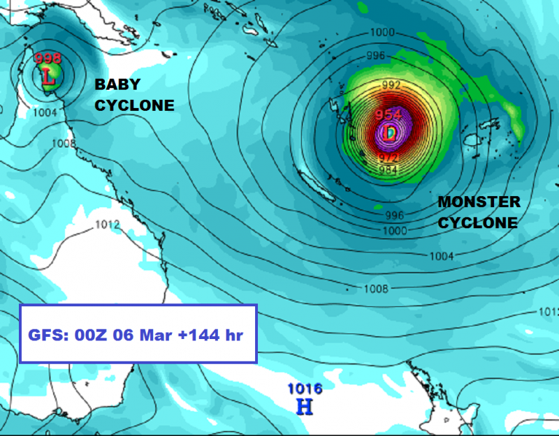
Friday evening (QLD, Australia): The computer models are predicting two *separate* cyclones may develop, and that’s created confusion. The models predict 1) a huge “monster cyclone” way out in the S Pacific (near the island nations) and 2) a “baby cyclone” in the Coral Sea (near Queensland). To avoid confusion, this page and Oz Cyclone Chasers will refer to these systems as “monster cyclone” and “baby cyclone” until they’re named by official agencies. Now that we've straightened that out, here’s what the latest (00Z) models are showing…

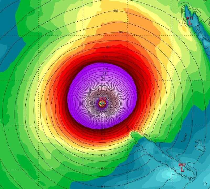
MONSTER CYCLONE: This is currently the disturbance called “Invest 93P” by the U.S. Navy. The Euro and GFS continue to predict it will develop into a large and powerful cyclone, and that it will trek S and SE, threatening S-Pacific island nations next week. Until a cyclone actually forms, it’s tough to know which island(s) will be impacted and when—so all islanders should keep watch (without freaking out).

BABY CYCLONE: Both models show a low developing in the Coral Sea and threatening the N part of the Cape York Peninsula. The GFS shows a weak (Cat 1/2) cyclone coming ashore in N QLD and then strengthening a little as it bounces back offshore. (Shown here is the GFS prediction for 6 days from now, with the system near land.) The Euro is less enthused about the baby cyclone—bringing it to the coast weaker and later (in about 8 days). (Base imagery from Tropical Tidbits.)


Anhänge:

Bitte Anmelden um der Konversation beizutreten.

  • Seite:
  • 1
Moderatoren: Tobias FerrariMarkus Brotschi
Ladezeit der Seite: 0.165 Sekunden
Zum Seitenanfang
JSN Boot template designed by JoomlaShine.com